A New and Correct Plan of the Town of Boston. And Provincial Camp
Original
Background Notes
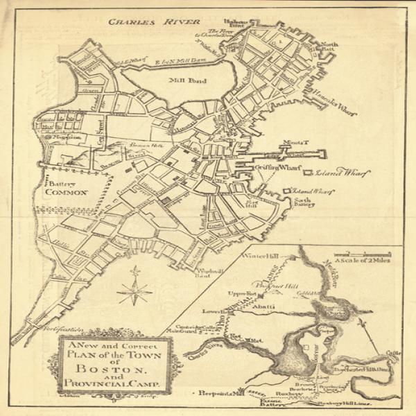
This map, which first appeared in the July 1775 issue of the Pennsylvania Magazine[1] shows a larger view of the town of Boston including the layout of the town and in the lower right corner, the siege of Boston with the line of provincial forces.
Prior to the mid-nineteenth century, when the Back Bay was filled in with topsoil, Boston was a peninsula with only a narrow strip of land called "The Neck" connecting the city to the mainland as indicated in the lower left portion of this map. Also note the large wharfs protruding into the harbor on the East, indicating the importance of the port to the region's commerce and trade. In 1770, Boston had a population of 15,520. [2]
This map also details the British battery on the common and their fortifications of The Neck. The inset on the lower right shows the provincial lines from Cambridge on the Charles River north to Winter Hill on the Mystic River. At the very bottom of the insert can also be seen the American lines opposite the British forces in the Roxbury area are visible at the very bottom of the insert. This map also indicates forts and artillery positions. [3]
After the Battles of Lexington and Concord some 10,000 provincial militia came from throughout New England and laid siege to Boston effectively stopping the British from leaving the town by land. George Washington took command of these troops as Commander in Chief on July 3, 1775. The siege was in place until the British evacuated Boston on March 17, 1776. [4]
1. Nebenzahl, Kenneth. A Bibiliography of Printed Battle Plans of the American Revolution 1775-1795. University of Chicago, 1975. pg, 3
2. Morris, Richard B. Encyclopedia of American History, New York: Harper
&
Bros., 1953. pg. 442
3. Nebenzahl, Kenneth. A Bibiliography of Printed Battle Plans of the
American Revolution 1775-1795. University of Chicago, 1975. pg, 4
4. Morris, Richard B. Encyclopedia of American History, New York: Harper
&
Bros., 1953. pg. 87- 90